
My two-day hike along the whole Worcestershire Way, from Great Malvern to Bewdley
Out of the hundreds of long-distance hiking trails that criss-cross Britain, the Worcestershire Way (WW) starts pretty much right outside my front door, so it seemed only right that I cross this one off my list sooner rather than later. At 31 miles (50 km), the WW is also comfortably doable within my fitness levels and money/time constraints. Many long-distance hiking paths, such as the Cotswold Way or Wye Valley Way nearby, can take weeks to do or cover hundreds of miles. That would be far too much for me, but a good two-day challenge was ideal.
So, I set off in mid-April, 2025 armed with an oversized camera, a few days’ spare clothing, and a book to stave off my internet addiction. (Peter. H. Wilson’s Europe’s Tragedy – the telling of the insanely convoluted 30 Years War, if anyone is wondering.) Most importantly, I went armed with three Ordnance Survey maps, covering the WW. Although I had read that the way is well marked, all it takes is one route marker to be missing and I could be up a creek without a paddle, scrambling through brush and brambles, spitting out twigs as I forlornly tried to find my way across the landscape with the sun descending towards the horizon and another five miles to my hike when I’m aching to be at the finish line. No, I did not want to be in that situation, again. The maps were therefore my failsafe.
Day one, I had just 11 miles to cover which gave me time enough to fuel up with a cooked breakfast then let it settle whilst I packed, trying not to do something ridiculous like forget to take underwear in the excitement of it all. The actual start point is in Great Malvern’s Belle Vue Island. The Malverns being the hills where lovely pure spring water gushes out of the rocks, Great Malvern developed into a health resort in the 18th-19th Centuries after a ‘Water Cure’ was contrived to which Britain’s rich and famous flocked to recover from their various ailments. One of Malvern’s most accessible springs is on the island and attracts people far and wide to stock up. So, naturally, I filled up my bottle before setting off.

And this is probably the most strenuous part of the whole hike, following the path that snakes up, past St Anne’s Well then up the steep Happy Valley until I’m 330 metres up on the path that skirts around North Hill and Table Hill. Although I’m quite used to the views as a local resident, I’m still awed by how the steep slopes loom over the town and Severn river valley to the East, and you’re very much looking down on the town just a short distance away from these mountain-like slopes. It is here, though, I, like others, find it a little bemusing that the WW doesn’t ascend to the Worcestershire Beacon just above. Surely the Worcestershire Way should include the highest point in the county that boasts the best views by a country mile? Well, it does not. Although, if one were coming in the opposite direction one may be happy to not have to climb the 425-metre peak at the very end.

It is fine hiking weather. We’ve already had an exceptionally dry spring so far but that dry run was forecast to end today, so I had resigned myself to hiking in the rain, but so far not a drop. I descend into West Malvern and start heading north, through orchards and fields with parades of apple blossom trees showing off their pink and white petals to add to the rich amount of greenery on show for this time of year. This part of the way goes along with the Geopark Way, a much longer trail that touches off at all the different hill-lands between Gloucester and Brignorth. But, we go our separate ways after crossing the A4103 and I start to enter the hillier terrain of the Suckley Hills and along a country lane with many lovely cottages.


I drop into Longley Green village and try to pick up some refreshments in the Post Office shop. This community shop, however, is going out of business and the shelves are almost completely empty. I buy a carrot for 8p – It’s either that or an onion – then, after lamenting with the volunteer cashier about the state of the post-CONVID economy, off I go chomping on my carrot and up along the first of several long, wooded ridgelines. Frankly that is what much of the WW is composed of, wooded ridgelines with little to see of the surrounding valleys but plenty of birdsong, peace, and forest flowers. Earlier, I had passed a large hiking party who were doing the WW in the opposite direction and I asked about the WW’s highlights. ‘Flowers’ she replied, and she wasn’t lying. Lots and lots of flowers along the many woodland paths; bluebells and dewdrops carpeted the ground around as I made my way north, through the Blackhouse Woods before I approach the Teme River which I cross before checking in at The Talbot at Knightwick.

THERE IS A dearth of places to stay along the Way, although The Talbot is one, and very nice for the night. £90 got me a small, comfy room and a relaxed welcome from the staff, with top-notch food and drink on offer. This traditional inn boasts its very own brewery and bakery, and was supplied by a butchers just over the river, so the quality was really there, though not cheap. I was up early and, with breakfast included, I justified wolfing down another full-English on account that I had 20 miles to cover this day and knew I was going to find it a struggle, especially with no places to buy snacks or drinks.
I head up the B4197 and then right into the Sunningdale estate, rich with bluebells. Then, into another woodland, it wasn’t clear which way to go and I got lost for the first time, down to me missing a route marker. I didn’t go off route far, but every time I got lost, it ate into my reserves of time, energy and momentum. Onwards around Martley and some lovely rolling farmland, and the sun stayed out. I then dropped down for a stretch along the banks of the Teme before climbing up to traverse another wooded ridgeline. Half way along and the woodland opens up into a hillside meadow and I could enjoy a rare panoramic view West and what were perhaps the Shropshire hills in the distance, and here is where I get my first rain shower. I drop down to skirt around the Woodbury Quarry pond then back up to continue along a ridgeline. Now, I’m approaching Abberley.
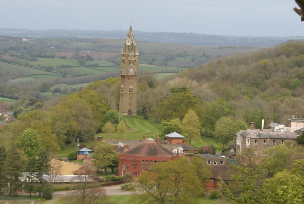
Again the route disappoints because it passes through very little of the village itself. Abberley also has one of the way’s few landmarks; the Abberley Clock Tower which, although supposedly visible from six counties, I didn’t notice at all because it was obscured by the woods.
I was now counting down the miles, the weight of my rucksack digging into my shoulders, my water run out and I dare not rest because I’m at the age where, if I sit for longer than five minutes, it’s painful getting going again. Now, I’m going up some of the highest terrain of the WW since I left Malvern as I negotiate the Abberley wooded ridgeline, including its trigpoint of 283 metres. I get lost again due to inconsistent route marking and asked a local woman if I’m going in the right direction, to which she confidently confirmed I was, but she is less than correct. More time and energy lost. I also notice, after descending the last of these ridgelines, that the Ordnance Survey maps are not entirely accurate; either that or the WW has been slightly altered since the map’s publication. I learn this while trying to find a path through bramble vines that scratch up my calves pretty good.
Now, I feel I’m on the home stretch and, if anything, it gets even sunnier which keeps my spirits up. But I’m feeling it now, the dull ache of my soles becomes harder to ignore and each incline takes more and more effort to overcome, yet I’m taking pride in what I’ll have achieved once I cross the finish line. I come across a sign saying ‘Bewdley 7.5 miles’ which dismays me a little as I was hoping it was closer to four miles. I trudge on; the farmland here is hilly and I see few other people.

I’m now on the home-run, although what inclines there are, are more and more drawn out. I pass through what looks like a golf course then edge around the Ribbesford Woods, looking earnestly for the River Severn. Finally, I reach the beautiful St Leonards Church with a graveyard full of apple blossoming trees and then I’m on Bewdley’s outskirts, passing through a couple of meadows but still no buildings in sight which is a bit of a tease at this stage.
Then, finally I pass down Lax Lane and come to the banks of the River Severn, and the town does not disappoint. Bewdley developed into a thriving trading hub on the mighty Severn and so is festooned with grand old 16th, 17th and 18th Century buildings along its riverside and beyond. I sight Bewdley’s bridge and ending point where I get a pic of myself before making the short walk to my hotel where I’ll be staying for two nights the Severn Valley Guest House; a pleasant place to stay for good value. After rushing to get checked in and bag off, I do the only sensible thing after 11 hours hiking; stumble into a pub for a pint of cider and ham & cheese cob. Lovely!
So there you have it. It was a good hike and challenge. It was also by-and-large exceedingly well marked out. It offered plenty of bucolic peace and woodland. Yet, there was not much to see along the way; some nice old buildings here and there but not a great deal to stay in the memory bank, unfortunately. The Worcestershire Way probably doesn’t make it into Britain’s top 40 paths, but I’d recommend it as a good route for inexperienced long-distance hikers at least.


Leave a comment